History of Sand Point Way NE
Sand Point Way NE is one of Northeast Seattle's oldest through-routes, and its history explains a lot about why the street looks the way it does today. Its genesis was to serve the then-rural area north of the Seattle city limits in the 1920s, adapted to serve as an arterial to service Naval Air Station Sand Point, spending more than fifty years as a state highway. As the city grew northward, the urban built environment caught up to its origins.
Before Sand Point Way
Sand Point was actually home to the original Carkeek Park! The park opened in 1900 on land donated by Morgan J. and Emily Carkeek. After the federal government acquired the Sand Point site to construct Naval Air Station Sand Point, Seattle Parks reassigned the name to the park now known as Carkeek in Northwest Seattle near Greenwood.
The area north of the future Naval Air Station was once known as Pontiac. Unlike Laurelhurst, which Seattle annexed in 1910, many neighborhoods around and north of the station did not become part of Seattle until 1953. Their late annexation helps explain why some streets developed without the sidewalks and other urban infrastructure found elsewhere in the city.
Development was also shaped by racially restrictive covenants that excluded people from neighborhoods based on race. The University of Washington's Seattle Civil Rights and Labor History Project documents covenants in Laurelhurst, Windermere, View Ridge, Sand Point Country Club, and part of Matthews Beach. Inverness was developed later in the 1960s, after such covenants were not seen as typical.
Built for the Navy, not the neighborhood
The road's modern history begins with the U.S. Navy. In 1926, King County transferred roughly 413 acres at Sand Point to the federal government, and the Navy established Naval Air Station Sand Point the following year. The new base needed reliable road access, so the City of Seattle officially named Sand Point Way and worked with King County to grade and pave it, giving the growing base a real connection to the rest of the city.
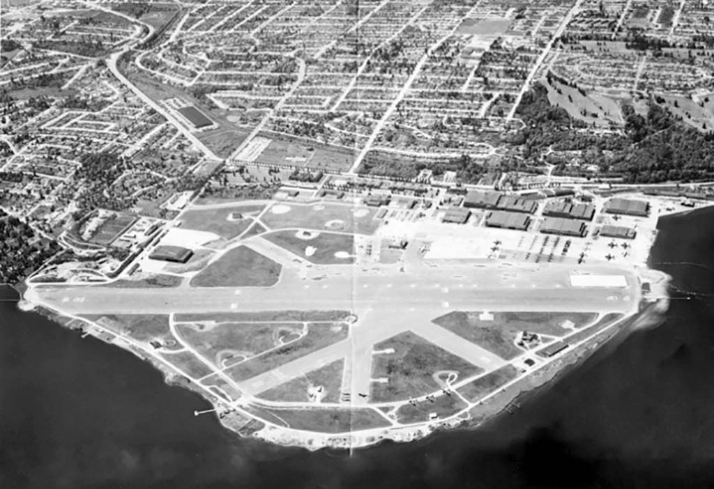
Sand Point Naval Air Station, Seattle, May 1953 Courtesy U.S. National Archives (via HistoryLink)
In its early decades, the road ran from 45th Street and Union Bay Place NE north to the Naval Air Station's gate near present-day Magnuson Park. The surviving Naval Air Station gatehouse at NE 77th Street is an Art Deco Seattle landmark.
A modest commercial strip grew alongside the road in the 1920s and 1930s. Dooley's Tavern opened near NE 73rd Street in 1926, and gas stations and corner groceries served the growing base and nearby residents. Sand Point Way and NE 97th Street once had stores on two corners and functioned as a much more active pedestrian intersection than it does today. North of the base, Sand Point Way narrowed to a two-lane country road that followed the crest of the hill alongside Lake Washington toward what is now known as Lake City.
Fifty-four years as a state highway
Sand Point Way's life as a state route began in 1937, when Washington designated it, together with Montlake Boulevard and University Way, as part of Secondary State Highway 1J. The 13.4-mile route connected Montlake to points north. Washington's 1964 highway renumbering turned SSH 1J into State Route 513.
SR 513 did not stay the same size for long. In 1971, the state shortened the route to 9.2 miles, anchoring its south end at the SR 520 interchange in Montlake and its north end at Interstate 5. The highway designation still extended north past Magnuson Park and through Lake City before meeting I-5.
That changed again in 1991, when the state truncated SR 513 to its current 3.6 miles and moved its northern terminus to the former naval station near NE 65th Street. The section north of Magnuson Park was relinquished by the state and handed to the City of Seattle as a city arterial.
That handoff is the origin of this project's name. The portion of Sand Point Way NE north of Magnuson Park is literally the road beyond SR 513. It left state ownership more than three decades ago, but its wide travel lanes, sparse crossings, and incomplete sidewalks still reflect its highway-era design.
The base closes, the neighborhood changes
As the Naval Air Station wound down in the postwar decades, the small commercial strip along Sand Point Way never grew into a neighborhood business district. By the 1960s, shoppers had shifted to larger stores in the Lake City commercial core near NE 125th Street and Lake City Way NE and other big grocers. The isolated corner stores and gas stations north of the old base gate gradually disappeared.
The former base became Warren G. Magnuson Park, named for the longtime Washington U.S. senator who helped negotiate the transfer of surplus federal land to the City of Seattle and the University of Washington. Today the park anchors the corridor's south end with trails, playfields, and access to the Burke-Gilman Trail.
Levy-funded improvements
Seattle voters funded three major transportation levies between 2006 and 2026. Both affected the corridor's maintenance and safety record, even before the current push for redesign.
Bridging the Gap (2006-2015)
Approved by voters in 2006, the nine-year, $365 million Bridging the Gap levy directed most of its funding (67%) to basic maintenance such as paving, sidewalk repair, bridge work, and tree care. At least 18% was set aside for pedestrian, bicycle, and school-safety programs, with up to 15% for transit and larger capital projects.
Along Sand Point Way NE, this era's investment was mostly maintenance-level: paving and spot repairs rather than the crossing and sidewalk overhaul the corridor needed.
Levy to Move Seattle (2016-2024)
Voters approved the larger, nine-year, $930 million Levy to Move Seattle in November 2015. Citywide, it funded more than 250 blocks of new sidewalks, roughly 68 miles of new bike facilities, three new bridges, and three RapidRide transit corridors. It also funded the Sand Point Way NE Corridor Project, the direct predecessor to today's advocacy effort.
The corridor project developed over several years. A neighborhood grant application in 2016 led to an SDOT transportation study in 2017, followed by public outreach, design, and construction between 2018 and 2021. The completed work included (see SDOT blog post):
- New curb bulbs and sidewalk sections at NE 123rd Street
- Removed slip lanes and new pedestrian-activated flashing beacons at NE 95th Street
- New pedestrian-activated flashing beacons near NE NOAA Drive
- Signal-timing upgrades at Princeton Avenue NE, NE 65th Street, NE 70th Street, and NE 74th Street
- Bike-connection improvements near NE 77th Street
Where things stand today
The Levy to Move Seattle work improved specific pinch points, but it stopped short of the continuous sidewalks, protected crossings, and slower design speeds the corridor still needs. This is especially true north of Magnuson Park.
Move Seattle concluded in 2024 and was replaced by a new, larger transportation levy, aptly named the "2024 Seattle Transportation Levy." The next round of funding decisions is an opportunity to address the corridor's remaining gaps.
Sources and further reading
- Sand Point Way NE: Stores and Stations at NE 97th Street, Wedgwood in Seattle History
- Along the Road from Pontiac to Sand Point Way NE, Wedgwood in Seattle History
- The very early history of Sand Point, HistoryLink
- Magnuson Park history, Seattle Parks and Recreation
- Washington State Route 513 history, Wikipedia